Home
|
:
Satellite TV - Dish
Pointing
Doing it Yourself
How to
Point a TV Satellite Dish
What you need to know: A Quick
Overview
1) Azimuth refers to the horizontal measurement of
a direction. In terms of your satellite dish, it tells you how far left or
right your dish should point.
2) Your elevation gives your
satellite dish its heading, or how far above the horizon it needs to point
(up and down).
3) Polarization also known as "skew", refers
to the adjustment needed for the curvature of the Earth. This rotational
adjustment compensates for the Earth?s curvature between the dish and the
beam of the satellite.
Your satellite TV provider can usually
provide the information you need. DISH Network for example features a
Point Dish/Signal option in their on-screen menu to help you in the
alignment of your satellite dish. Using your zip code, you can find the
azimuth, elevation and skew.
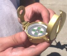
With your azimuth and elevation
numbers in hand, get a compass. Standing close to your satellite
dish, rotate your compass until the needle points North, or zero degrees.
Starting from this point, locate the azimuth number on the compass and
turn to face that point without moving the compass itself. East is 90
degrees, South is 180 degrees and West is 270 degrees. If your azimuth
number is 240 for example, you would face a direction between South and
West on your compass.
Now that you?ve found your direction
(left/right), estimate the angle of elevation (up/down). With the ground
representing zero, calculate the distance going upwards using the
elevation number. Straight up would be 90 degrees, so if your elevation
number was 45, your elevation would be halfway between the ground and
looking straight up into the sky.
It is important to note, your dish antenna must be installed correctly
before you can attempt to align your dish to the correct satellite to
receive satellite TV signals. Some things to keep in mind:
- If you just bought a new satellite TV system, free installation was
probably included and therefore you do not need to align your dish
yourself as this will be done by the installer.
- Two-way (send and receive) Internet requires professional
installation IAW FCC rules.
- There are many satellites in the sky. It's easy to think you are
pointing at the right one when you are really pointing at another.
Satellites are often shared by multiple companies though some have their
own for their own customers. DirecTV?, DISH?, and DirecWay? use
different satellites, different frequencies and sometimes even multiple
satellites.
- If you've purchased a DIRECTV Multi-Satellite System, it is highly
recommend that you have it professionally installed. This system
features an 18x24-inch oval dish, which allows reception from all three
DIRECTV orbital locations ? 101, 110 and 119 degrees West Longitude
(WL). To receive signals from all of these locations, your DIRECTV
Multi-Satellite dish must be aligned by tilt as well as elevation and
azimuth. This technical requirement makes the installation more complex.
Pointing your satellite dish antenna to the correct spot in the sky
to receive satellite TV signals is a task which can be accomplished by
anyone with the knowledge and desire to do so. However, depending on your
particular setup, you may need some additional help.
Aligning a satellite antenna (dish) to a broadcast satellite for the
purpose of receiving a signal.
We live in a three dimensional
world. You can think of the three dimensions as height, width and
depth.
For purposes of aligning your dish antenna, we will call height,
elevation and we will call width, azimuth. Azimuth is just a fancy word
for direction. The depth would be the distance from your dish to the
satellite or about 22,000 miles. To receive your satellite TV signal from
the correct satellite you must point your dish to a specific spot in the
sky which will give you the best possible signal strength. This spot is
the location of your satellite in space. The question is, how do you
determine exactly where to point your dish?
Some of the work
has already been done for you by the satellite TV provider companies. The
angles you need to point your dish have been setup in the satellite TV
providers on-screen menu. All you have to do is enter your ZIPCODE and you
will get back the elevation and azimuth angles for your specific location
and for the satellite you are trying to point to in order to get your
programming.

On-screen menu for dish alignment and signal strength (Dish
Network)
You select the satellite you need for your TV programs and
then enter your ZIPCODE
Once you know the elevation and azimuth
angles for your location / satellite, your task is to set your dish to
these angles.
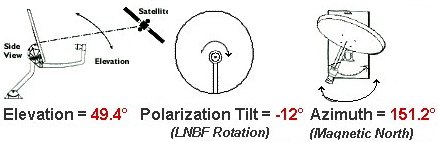
When aligning a dish antenna to a satellite, there
are three (3) important variables that need to be adjusted in order to
properly receive the strongest signal.
-
Elevation - Angle between the Earth and the satellite, above
the horizon. This is also referred to as the up or down movement
(position) of the satellite antenna (dish). Elevation is measured in
degrees. Elevation is the upward tilt of a satellite antenna, measured
in degrees, required to aim the antenna at the satellite. Think of
elevation as follows: If you stand straight up and look out to where the
land meets the sky (horizon) hold your arm straight out and point to the
horizon, this is zero degrees elevation. Start moving your arm up slowly
and point to the sky. You are now elevating up in degrees. When you get
to where your arm is straight up pointing to the sky right above your
head, this is 90 degrees. What you'll be looking for when pointing your
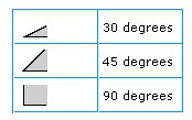
dish is an angle somewhere in between zero and 90, most likely 30
(northern states) to 55 (southern states).
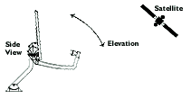
Elevation
-
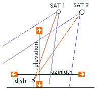
Azimuth - Compass direction the antenna is pointed towards,
relative to a magnetic north. This is also referred to as the left or
right movement (position) of the satellite antenna. The angle of
rotation (horizontal) that a dish antenna must be rotated through to
point to a specific satellite in orbit. The angle is a north to south
line through the antenna?s location, measured in degrees
clockwise.

Azimuth examples
-
Polarization - Correction between where the antenna is
relative to the curvature of the Earth and the satellite?s signal beam.
The satellite signal is either Horizontal or Vertical polarized, but due
to the longitude of the antenna location, the antenna?s feed horn must
be rotated to correctly match the beam's
polarization.
Determining the Elevation and Azimuth
The DBS
satellites (Dish Network & DirecTV) appear to be fixed in space
approximately 22,300 miles above the equator. In reality, the satellites
travel from west to east, but to us on Earth they appear stationary
because they match the exact speed of the Earth's rotation. (This is a
geostationary orbit.) If you stand up now, turn towards the southern sky,
and tilt your head up to the heavens, you'll be looking in the general
direction of the DBS satellites.
To aim your satellite dish antenna
at the DBS satellites, you need to know your azimuth and elevation
coordinates. Azimuth is defined as the horizontal direction expressed as
the angular distance between the direction of your dish and the direction
of the DBS satellites. More simply, azimuth relates to the
left-to-right positioning of your dish. Elevation is the angular
distance of the DBS satellites above the horizon in relation to your dish.
In other words, elevation concerns the up-and-down positioning of
your dish.
Your satellite TV Receiver is programmed to give you
these coordinates and help point your dish to the correct spot. You'll
find this assistance in the on-screen Setup Menu. The menus vary from
system to system, so check your owner's manual.
Further
explanation: A geo-stationary satellite in orbit around the Earth
remains above the same location on Earth since it's orbit is in synch with
the Earth's rotation. The satellite transmits it's signal to Earth after
receiving it from an Earth ground station. Your dish antenna captures the
signal and focuses it on the LNB which feeds it down a cable to your
receiver which decodes it and sends it to your television. The dish
antenna has to be aligned properly so that it can capture the signal. It
has to be pointed towards the signal and fine tuned for maximum signal
strength.
For each location on the Earth's surface which can
capture a particular satellite signal, you have to align the dish at
different angles to receive the best signal. Everyone in the Northern
hemisphere of the Earth (includes the United States) has to point their
dish towards the southern sky since the satellites you require are
positioned over the equator. A dish in North Dakota has to be pointed
lower than a dish in Texas. A dish in Florida has to be pointed
differently than a dish in California.
The good news for consumers
is that all the calculations have already been worked out. For any given
location with a zip code in the U.S. you can find out what angles you need
to properly align your dish for your location to receive your satellite TV
provider's TV programming. Once you connect your satellite TV receiver to
your television and have your dish antenna setup and installed properly,
you just enter your zip code in the setup menu for pointing your dish
(your satellite TV receiver should be programmed for all the satellites
you can get to for your programming) and the alignments are presented for
you to use to align your dish antenna.
For example - Zip
Code - 78759 (Austin, Texas) the azimuth and elevation for the DirecTV 110
west longitude satellite are:
| Azimuth |
183.0 |
| Elevation |
54.5 |
So you would elevate
your dish to 54 degrees elevation and turn your dish to 183 degrees
azimuth.
These numbers should seem logical based on your location
and the location of the DBS satellites. The DBS satellites are in space,
positioned above the imaginary lines of longitude running thru the United
States in the areas passing thru Tucson, Arizona (110 degrees west) and
Reno, Nevada (119 degrees west) among others, but these are the two
carrying the bulk of the TV programming. If you live in Miami,
Florida, you would expect to point your dish much more to the west than
someone in Dallas, Texas. Likewise if you live in Minneapolis, Minnesota,
you would expect to point your dish lower in elevation than someone in
Austin, Texas.
The following chart shows some examples
of locations with approximate azimuth and elevation angles for the DirecTV
110 degree West longitude satellite.
| Zip Code |
Location |
Azimuth |
Elevation |
| 33196 |
Miami Florida |
225 |
52 |
| 10010 |
New York N.Y. |
231 |
35 |
| 75210 |
Dallas Texas |
181 |
52 |
| 78759 |
Austin Texas |
183 |
54 |
| 55408 |
Minneapolis Minnesota |
188 |
38 |
| 85708 |
Tucson Arizona |
149 |
51 |
| 90072 |
Los Angeles Calif. |
151 |
46 |
| 98109 |
Seattle Washington |
133 |
31 |
For the DirecTV 110 west longitude satellite, if you lived in Los
Angeles CA, your numbers would be:
| Country |
United States |
Time Zone |
PST |
| City |
Los Angeles |
Latitude |
34.0960 deg. N |
| State |
CA |
Longitude |
118.3086 deg. W |
| County |
Los Angeles |
Azimuth true North |
165.4 deg. |
| Distance to satellite |
37,118 Km |
Magnetic deviation |
14.17 |
Now that you have your azimuth and
elevation coordinates, what do you do with them?
Set up your
dish antenna to ensure an unobstructed line of sight to the satellites. To
receive satellite broadcast signals, your dish needs to be positioned
correctly. Mount your dish so that the base fits flush with the mounting
surface (level if mounted on a flat beam or roof, or on an angle to match
the pitch of your roofline). When you have securely mounted your dish,
adjust it so the dish mast is plumb, that is, exactly perpendicular to
level ? this is best achieved using a carpenter's bubble level. With your
dish now mounted and properly set, you are ready to aim your dish toward
the proper satellites.
To set the dish to point up to the
satellites, you'll first need to set the elevation. Then you'll point the
dish in the proper left-to-right position to set the azimuth.
For
anyone in the U.S., begin by pointing your dish to the South. If you do
not know where South is you can use a general purpose compass to determine
North and South.
Setting the Elevation (UP), (DOWN)
You can
set the proper elevation after the dish is securely mounted. First, loosen
the nuts securing the two elevation bolts so that the dish easily moves up
and down. Line up the elevation indicator with the tick mark corresponding
to your elevation number. Then tighten the bolts.


Setting the Azimuth (LEFT),
(RIGHT)
Loosen the azimuth nuts on the LNB arm enough that the
dish can be turned smoothly with little pressure. Set the azimuth by
moving the dish left and right. Point the dish in the general direction of
the satellite, in the southern sky. By using a compass you can better
pinpoint the direction with your azimuth number to correspond with the
degrees on your compass.
Acquiring the Signal
Now
your dish will be in position to lock in on the satellite signal. You'll
need to
1) have your satellite receiver connected to your
television, with both turned on, and
2) have your antenna to
receiver cables connected, and
3) be viewing your Setup
Antenna/Signal Strength display from your on-screen menu to measure the
signal strength accurately.
Ask someone to watch the Signal
Strength screen for indications you are receiving the signal. Stand behind
the dish, and holding its outer edges, slowly turn it a little to
the right to adjust the azimuth. Pause a few seconds, giving the receiver
enough time to lock in on the satellite signal. Continue turning the dish
in this way until you have acquired the signal or until you have rotated
the dish approximately 15 degrees from the starting point.
If you
haven't detected a signal yet, return to the starting point and move the
dish to the left again. If you don't acquire the signal after rotating the
dish approximately 15 degrees to either side of the calculated azimuth
angle, loosen the elevation bolts and tilt the dish upward so the
elevation indicator moves halfway from the current tick mark to the next
mark. Then tighten the elevation bolts. Repeat the azimuth adjustments
again to lock in on the signal.
If the signal still eludes you,
check:
- that nothing ? a tree, for example ? obstructs the signal
- that the cables are connected properly to the receiver
- that you have the correct azimuth and elevation
coordinates
Fine Tuning
When you have received
the satellite signal, it is important to fine-tune the dish pointing to
make sure you have the maximum possible signal strength. Maximizing the
signal is important in that it reduces "rain fade" during inclement
weather. Loosen the elevation bolts, then gently continue turning the
dish a little in the same direction you were turning it when you began
to receive the satellite signal. Pause for a few seconds each time after
moving the dish. Turn the dish in this way until the signal strength
reaches its highest reading and then begins to fall. Then slowly turn
the dish the opposite way until you again receive the highest reading on
the Signal Strength screen.
Important: The Signal
Strength reading does not need to be "100." Lock in on the highest
possible signal which is usually 70 to 85.
Tighten the azimuth
bolts. Loosen the elevation bolts. Slowly tilt the dish up and down to
improve the Signal Strength reading. When you are satisfied that you
have the strongest signal, tighten the elevation bolts.
If you've purchased a Multi-Satellite System, it is highly
recommend that you have it professionally installed. These systems feature
an 18x24-inch oval dish, which allows reception from three orbital
locations (110, 119, etc., degrees West Longitude). To receive signals
from all of these locations, your Multi-Satellite dish must be aligned by
tilt (skew) as well as elevation and azimuth. This technical requirement
makes the installation more complex.
What if I cannot find the
correct satellite TV signal?
There are many online help web pages
available to provide information for you to use in pointing your
dish.
The census bureau of the federal government has a web page
which provides latitude and longitude for any ZIPCODE in the U.S. You can
also get the name of the city.
http://www.census.gov/cgi-bin/gazetteer
will
give you your exact latitude and longitude based on your entered
ZIPCODE
Now that you have your location's latitude and longitude,
you can go to
http://www.sadoun.com/Sat/Installation/Satellite-Heading-Calculator.htm
and
enter your satellite provider's satellite name along with your latitude
and longitude to
calculate your elevation and azimuth (geographic)
angles.
Another website to look at for azimuth & elevation
calculation: http://www.satcruiser.com/azel.htm
You may need to adjust your azimuth angle to account for magnetic
declination.
The website http://www.lyngsat.com/ will show you
information about satellites and programming and more.
Other
tools to help you:
Satellite Finder - meter

For $20 to $40 you can buy a meter which connects between
your dish and your receiver. The analog scale shows a satellite signal
when present. This can be used to find and fine tune a
signal.
Digital meter satellite finder
For around
$400 you can get a digital finder which shows you satellite names, signal
strength and quality.
One brand name is Birdog.

Display on digital satellite finder box shows satellite name,
location, signal strength and quality.
This box connects between the
dish and receiver to help find your satellite and fine-tune the
signal.
Other things to consider if you cannot find your
satellite signal:
1) You may have a bad satellite TV receiver.
Ask your provider to swap receivers or try another compatible
receiver.
2) Your cable connections may not be tight or they may be an
improper type (use RG-6).
3) Dish may not be installed correctly.
4)
You may have a bad LNB. Try another.
5) Satellite TV provider may not
have your account activated properly.
6) Most satellite TV signals are
encrypted, meaning you may have the correct dish alignment but cannot get
a picture because your decryption card/software may not be updated.
Contact your provider.
7) TV set not on correct channel. Typically
channel 3 or 4 is used.
Satellites in orbit with their
locations
?61.5 EchoStar 3 @
61.5?
?110.0 DirecTV 1 @ 110.0?
?110.0
EchoStar 5 @ 110.0?
?119.0 DirecTV 6 @
119.0?
?119.0 EchoStar 4 @ 119.0?
?119.0
EchoStar 6 @ 119.0?
?148.0 EchoStar 1 @
148.0?
|


